Explore the Coastal Way in Wales

The Coastal Way in Wales is one of three national routes that take you through some of the country’s most dramatic landscapes and fascinating historical sites, as Steve Pill discovers
Ramsey Island sits just half a mile off the “big toe” of Wales, the most westerly tip of the country that is closer to Wexford in Ireland than it is the Welsh capital of Cardiff. It is separated from the mainland by a reef of rocks and tidal rapids known as The Bitches which stretch out into Ramsey Sound and have been responsible for a number of fatal shipwrecks over the years.
The island boasts an official population of two, yet the huge quantity of Atlantic grey seals and harbour porpoises living in the surrounding waters, not to mention the vast RSPB Nature Reserve contained within, makes this far from a lonely isle.
Photographers, nature lovers and awestruck families regularly make the round-island boat trip, keen to spot guillemots, razorbills and other seabirds nesting here, as well as the lunar-like landscape on the island’s west coast, a breathtaking collection of sea caves and rock gorges. It can seem otherworldly here at times, yet Ramsey Island also provides a full-stop to the end of the Coastal Way, a 180-mile long tourist trail mapped out by Visit Wales that arches around the whole of Cardigan Bay and takes in much of the best that the country has to offer.
The Coastal Way is Wales at its most dramatic and photogenic; a quainter, more manageable alternative to the vast expanse of Scotland’s western isles that can be explored in its entirety or dipped into along its length.
Back on the mainland from Ramsey, the Coastal Way picks up in Britain’s smallest city, St Davids. A population of less than 2,000 makes this smaller than many villages, yet the appearance of a cathedral means it is recognised as a city. St Davids Cathedral was consecrated in 1131 and building work began half a century later, not long after a visit from King Henry II. The A487 begins here and it is this trunk road to which the Coastal Way cleaves for much of its length.
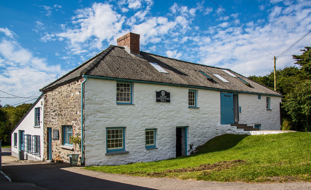
After the detour to the 200-year-old Melin Tregwynt Mill, with its working looms and excellent shop stocked with traditional woollen goods, the first key stop is Fishguard which balances a working port with the pastel-coloured cottages of the Lower Town.
The town is often used as a base for walks eastwards through the Gwaun Valley via the six-acre Dyffryn Fernant Garden to Pontfaen, while it gets busy at the end of July for the annual, classical-oriented Fishguard International Music Festival. The history of the town, meanwhile, is neatly encapsulated in The Last Invasion Embroidered Tapestry, Fishguard’s own answer to the Bayeux Tapestry. Housed in the local library, Elizabeth Cramp’s 100-foot long piece of needlework was commissioned on occasion of the bicentenary of the last invasion of mainland Britain in 1797, when French forces landed three miles west of Fishguard.
The estuary town of Newport isn’t an immediately obvious destination, yet time spent here reveals its gentle charms. The Newport Sands Beach is one of the loveliest along the North Pembrokeshire coast, while the stylish Llys Meddyg Hotel is popular with couples. This former Georgian coaching house has a cellar bar that dates back 500 years, while the market garden once grew flowers to sell in London’s Covent Garden.
After Newport, look out for signs for the Pentre Ifan Cromlech, a Neolithic burial chamber made from the same local ‘bluestones’ that were shipped 250 miles west to form Stonehenge, and the Castell Henllys, rebuilt Iron Age roundhouses at the heart of a 30-acre national park. Both add to the air of mysticism that has hung over Pembrokeshire for a millennium, ever since the author of the 11th-century The Mabinogion folk tales first described it as a land of mystery and enchantment.
This continues as the Coastal Way stretches across Cardigan Bay into the neighbouring county of Ceredigion, which is roughly based around an ancient kingdom of the same name that emerged following the Roman occupation of Britain in the 5th century.
One of the highlights of Cardigan is the 13th-century castle and the early 19th-century manor house contained within it, though this wasn’t always the case. The original motte-and-bailey castle never truly recovered from damage sustained during the English Civil War, while Castle Green House was finally deemed unfit for human habitation in 1984. The site has since undergone an award-winning, £12-million refurb documented loving
on the BBC TV series Restoration in 2004.
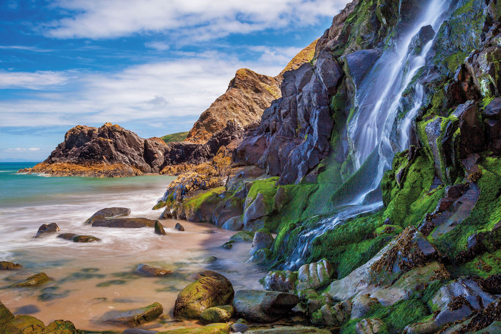
The best views of Cardigan Bay can be had by taking a walk to the top of Foel y Mwnt, a grassy headland that also overlooks the secluded, National Trust-maintained beach of Mwnt. During summer months, rangers from the Trust are also on hand at Mwnt to stage regular Dolphin Watch events as the mammals often venture into the bay. More cosy beaches can be found along the Heritage Coast at Penbryn and Tresaith, the latter complete with a waterfall caused as the River Saith bundles over the cliffs.
Next along the Coastal Way is Aberaeron, a town that sprang up in the late Georgian era after plans were made to build a harbour at the mouth of the River Aeron (Aberaeron literally meaning “the mouth of the River Aeron” in Welsh). While the colourful, three-storey townhouses are often strewn with bunting, the finest example of local period architecture lies a couple of miles down river at Llanerchaeron. The villa was designed around 1795 by the then-unknown architect John Nash, who would go on to become one of the leading lights of the Regency era, most famously with designs for Buckingham Palace, Marble Arch and Brighton’s Royal Pavilion. If it lacks the scale of those places, Llanerchaeron does at least contain many of the trademarks of Nash’s style already, from the largely square plan to the symmetrical facades with classical touches. Today visitors can explore the dairy, laundry and a walled garden that is home to fruit trees dating from Nash’s day, as well as the working pig, sheep and cattle farm – the only in-hand Welsh farm on the National Trust’s books.
The A487 continues right the way through Aberystwyth, an ancient market town that is the most populous place in Ceredigion. The hills around the town fall sharply into the sea, so much so that a funicular was opened in 1896 with a view to connecting the arcades and mile-long seafront promenade at the bottom with a camera obscura and landscaped park at the top that are both still open to visitors today. A 360-degree, birds’ eye view of the town is projected on the wall of the camera obscura in realtime via the vast 14-inch lens. Back at the bottom, the opposite end of the promenade boasts the oldest pier in Wales, dating back more than 150 years.
As the Coastal Way snakes around the mouth of the River Dyfi before reaching Machynlleth, look out for Ynyshir, a Michelin-starred restaurant with rooms named after famous artists, which was once owned by Queen Victoria who used the hall as a private coastal retreat and planted several of the trees growing in the garden today. You can only stay for one night at a time but chef Gareth Ward will make it worth your while with a tasting menu filled with Welsh produce and Japanese flavours.

From here, the route skirts the edge of the Snowdonia National Park in the shadow of the great mountains and rounds Cardigan Bay to the 20th-century Italianate village of Portmeirion [see issue 208] with its higgledy-piggledy arrangement of quaint colourful buildings.
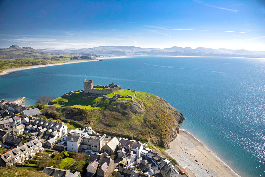
The town of Criccieth, meanwhile, is dominated by the beautiful ruin that is Criccieth Castle. The English artist JMW Turner saw the romance in the castle, painting a watercolour of it in its dilapidated state, yet viewing it high on the headland from the beach below, adding the drama of a storm to a famous watercolour that is now in the Tate collection. The 13th-century castle’s imposing gatehouse and towers were first built by the Welsh prince Llewellyn the Great as a statement of power, and they were later expanded by his grandson, Llewellyn the Last. Strangely, it was destroyed in 1404 by another Welsh prince, Owain Glyndwr, though only because it had fallen into English hands.
Just outside Criccieth is the Lloyd George Museum, dedicated to the life of David Lloyd George, the British Prime Minister who served from 1916 and 1922. His childhood home of Highgate forms part of the museum, which also contains his desk, a film about his life and his personal draft of the Treaty of Versailles, the document that brought peace at the end of the First World War.
After the beautiful beaches of Porth Neigwl and Llanbedrog, the Coastal Way comes to an end on the Llyn Peninsula, a designated Area of Outstanding Natural Beauty, and the former fishing village of Aberdaron. It developed as a port and shipbuilding centre from the 18th century onwards, with the old pier at Porth Simdde marking the point at which much of the locally quarried limestone, lead and other materials would be loaded onto ships and exported. It was a precarious industry thanks to the rocky waters around the bay which have been the cause of many shipwrecks, including the Liverpool-bound John the Baptist schooner which was wrecked on Aberdaron Beach in 1752.
As industry declined after the First World War, tourism took hold with visitors drawn to the promise of “the salubrious sea and mountain breezes”. Discover more about Aberdaron’s fascinating history at the thoroughly modern Porth y Swnt visitor centre. On your tour of the town, be sure to look out for Plas yn Rhiw, a gorgeous National Trust house with ornamental gardens overlooking the bay, and the Old Post Office designed
by Portmeirion architect Clough Williams-Ellis.
If Ramsey Island is the Coastal Way’s full-stop then Bardsey Island provides similar punctuation at the opposite end. Known in Welsh as Ynys Enlli, this is the “Isle of 20,000 Saints” thanks to a 6th century monastery being built here, and it is also reputedly the burial place of the legendary King Arthur (though many places claim the same). Boat trips allow visitors to explore the dramatic landscape and local wildlife, including migrating seabirds and grey seals, and the island also marks the end of the North Wales Pilgrim’s Way, a 134-mile route that has recently been given new waymarkers. That is a route for another time. For now, it is time to relax and enjoy the end of the Coastal Way and reflect on a remarkable odyssey around Wales’s wild west coast.
